Datei:Geopolitical map of Canada.png
Zur Navigation springen
Zur Suche springen

Größe dieser Vorschau: 680 × 599 Pixel. Weitere Auflösungen: 272 × 240 Pixel | 545 × 480 Pixel | 872 × 768 Pixel | 1.162 × 1.024 Pixel | 1.280 × 1.128 Pixel
Originaldatei (1.280 × 1.128 Pixel, Dateigröße: 545 KB, MIME-Typ: image/png)
![]()
Diese Datei und die Informationen unter dem roten Trennstrich werden aus dem zentralen Medienarchiv Wikimedia Commons eingebunden.
![]()
Beschreibung
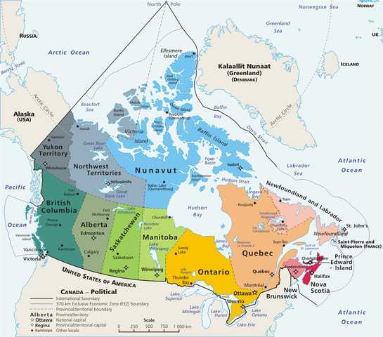
Español: Mapa político de Canadá!, con 10 provincias y 3 territorios.
This is a geopolitical map of Canada, drawn by User:E Pluribus Anthony. Source: en:Image:Map Canada political-geo.png
| Dieses Werk wurde von seinem Urheber E Pluribus Anthony in der Wikipedia auf Englisch als gemeinfrei veröffentlicht. Dies gilt weltweit. In manchen Staaten könnte dies rechtlich nicht möglich sein. Sofern dies der Fall ist: E Pluribus Anthony gewährt jedem das bedingungslose Recht, dieses Werk für jedweden Zweck zu nutzen, es sei denn, Bedingungen sind gesetzlich erforderlich. |
| Bildnotizen | Diese Datei ist annotiert: Betrachte diese auf Commons. |
Dateiversionen
Klicke auf einen Zeitpunkt, um diese Version zu laden.
| Version vom | Vorschaubild | Maße | Benutzer | Kommentar | |
|---|---|---|---|---|---|
| aktuell | 18:32, 5. Mai 2020 | | 1.280 × 1.128 (545 KB) | Leonel Sohns | Edited |
| 04:18, 10. Apr. 2006 |  | 1.280 × 1.128 (493 KB) | E Pluribus Anthony~commonswiki | Map: Canada – geopolitical | |
| 20:31, 29. Mär. 2006 |  | 1.280 × 1.128 (494 KB) | Anchjo | This is a geopolitical map of Canada, drawn by en:User:E Pluribus Anthony. Source: en:Image:Map Canada political-geo.png {{PD-user-wikimedia|E Pluribus Anthony|en}} Category:Maps of Canada |
Dateiverwendung
Die folgende Seite verwendet diese Datei:
Globale Dateiverwendung
Die nachfolgenden anderen Wikis verwenden diese Datei:
- Verwendung auf ast.wikipedia.org
- Verwendung auf cs.wikipedia.org
- Verwendung auf diq.wikipedia.org
- Verwendung auf en.wikipedia.org
- Verwendung auf eo.wikipedia.org
- Verwendung auf es.wikipedia.org
- Verwendung auf fr.wikipedia.org
- Verwendung auf gl.wikipedia.org
- Verwendung auf it.wikipedia.org
- Verwendung auf ko.wikipedia.org
- Verwendung auf lfn.wikipedia.org
- Verwendung auf mt.wikipedia.org
- Verwendung auf mzn.wikipedia.org
- Verwendung auf pl.wikipedia.org
- Verwendung auf sw.wikipedia.org